
Floorable
Floorable is an AI-assisted indoor mapping platform
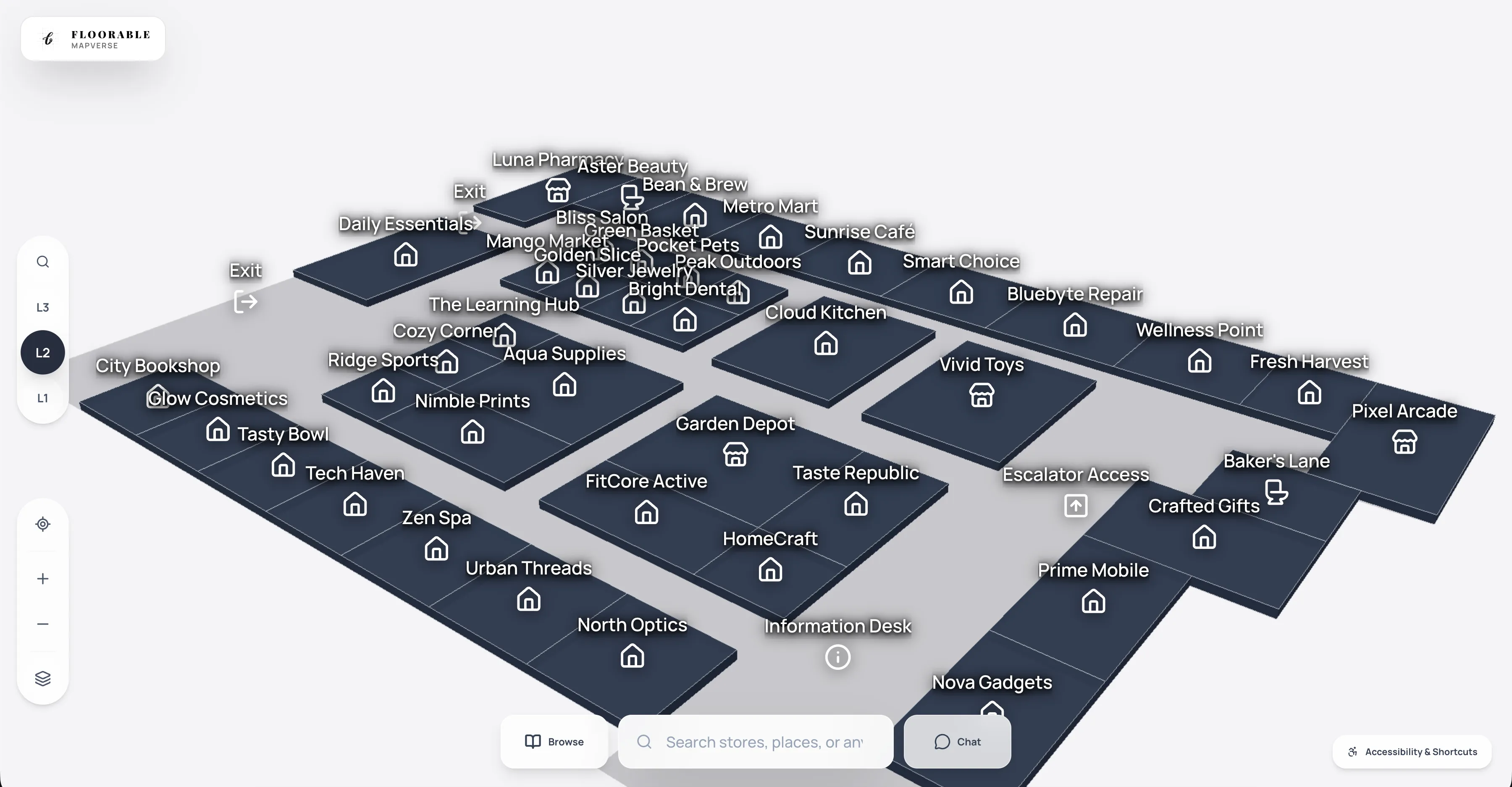
Floorable accelerates the transformation of complex facilities by combining high-fidelity Computer Vision with AI-assisted refinement to create route-ready indoor maps. The platform bridges the gap between guest experience and facility operations, offering intuitive 3D wayfinding for visitors alongside spatial ticketing and data-driven insights for maintenance teams. By removing traditional per-floor pricing barriers, Floorable enables organizations to map their entire portfolio with unlimited floors and granular control over accessibility and routing. Our workflow focuses on high-accuracy refinement and professional verification, ensuring that every digital twin is not just a visual asset but an operationally sound tool for high-stakes environments like hospitals, malls, and campuses.
Features
Based on the Floorable product overview and landing page, here are the core features and primary use cases:
Core Features
- AI-Assisted Auto-Detect Engine: Uses Computer Vision and OCR (via OpenRouter/Gemma) to rapidly digitize walls, rooms, and labels from static floor plan images.
- Professional Studio Editor: A robust, canvas-based editor with 30+ validation rules for precise structural and semantic floor plan refinement.
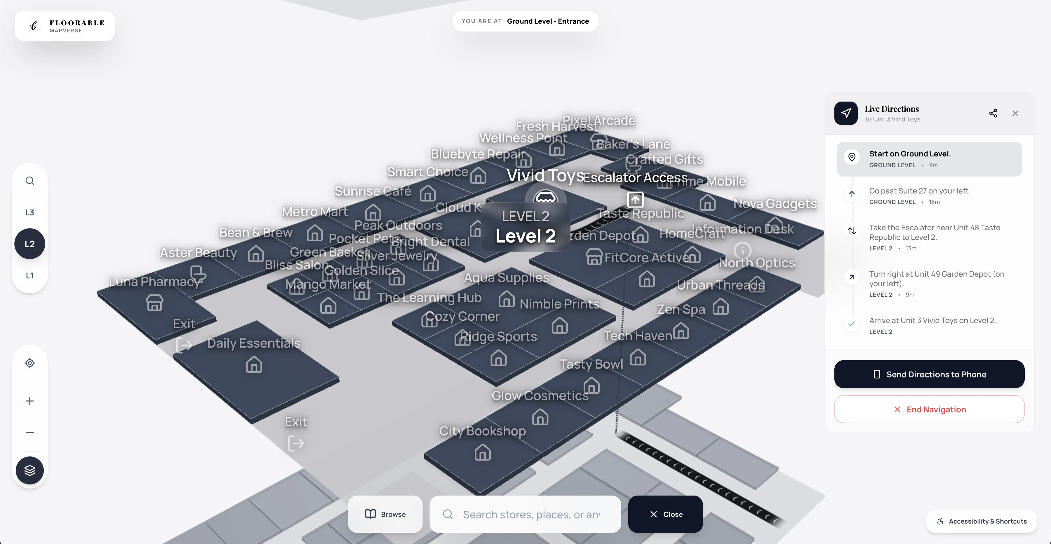
- Mapverse 3D Viewer: A high-performance Three.js-powered viewer that renders interactive 3D maps directly in the browser or on mobile.
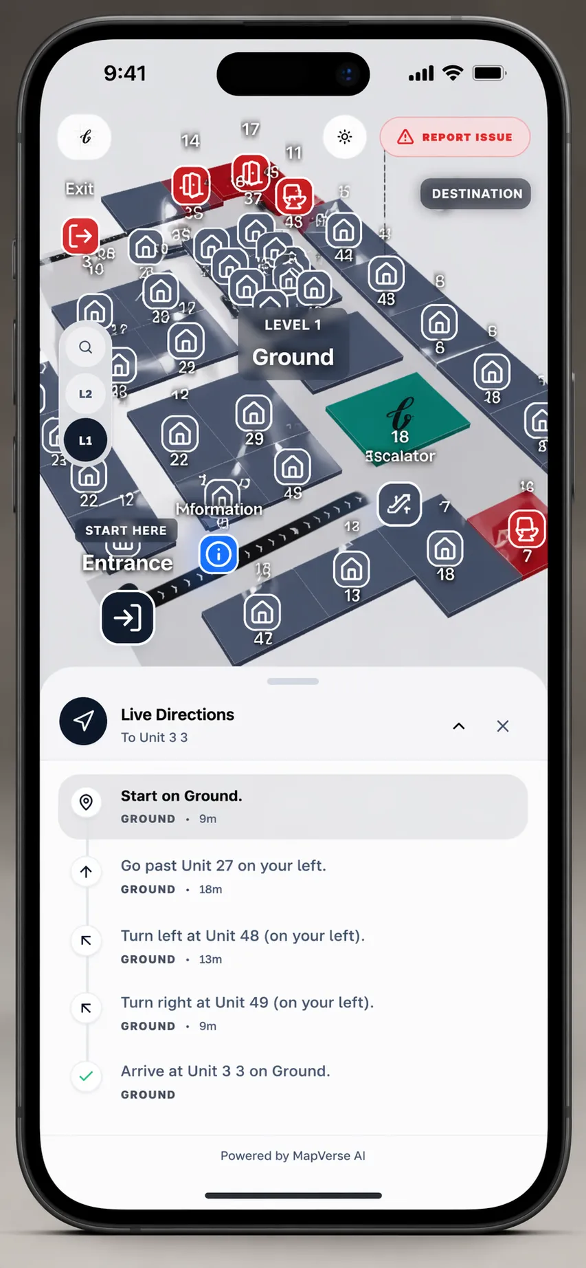
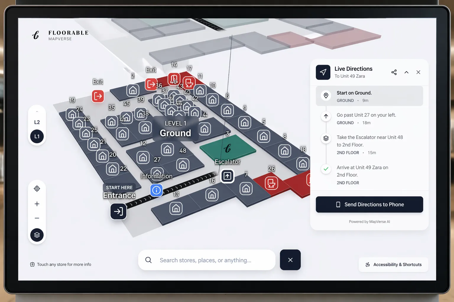
- Multi-Floor Routing Engine: Intelligent path-finding that seamlessly links floors via elevators, stairs, and escalators for comprehensive building navigation.
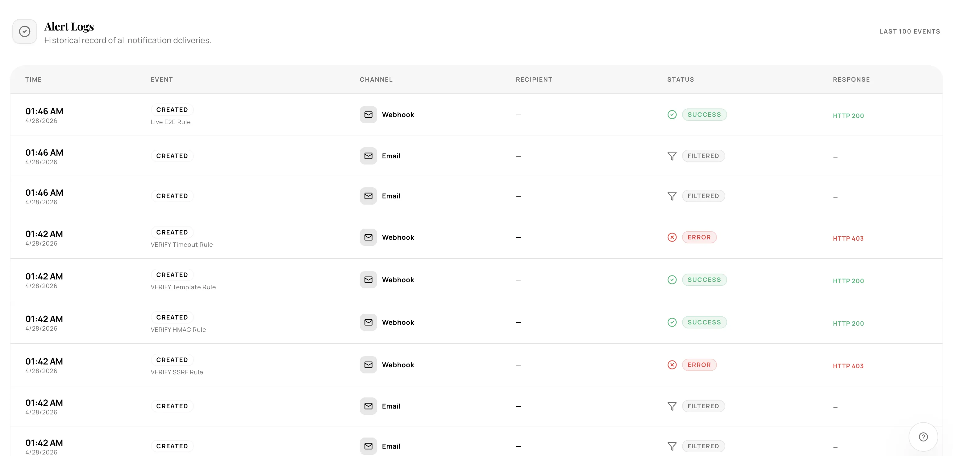
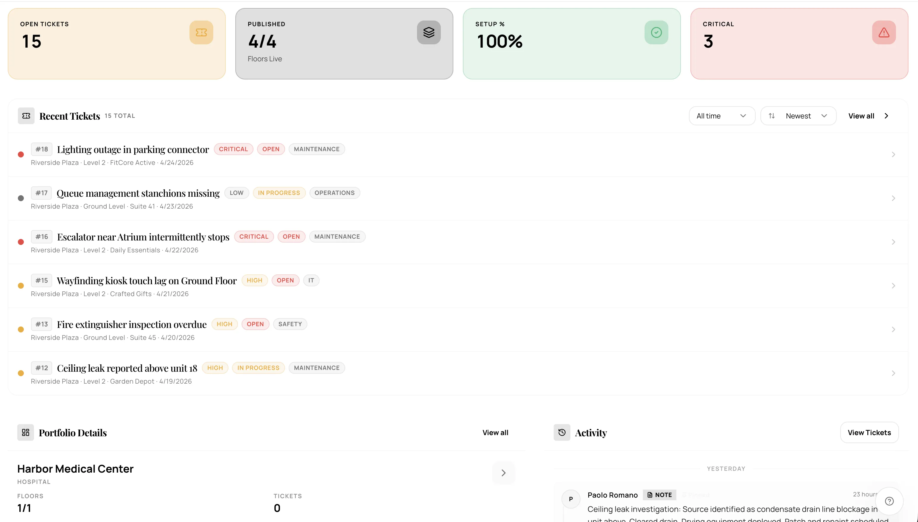
- Spatial Ticketing System: Allows facility teams to pin maintenance tickets directly to precise map locations for streamlined operations.
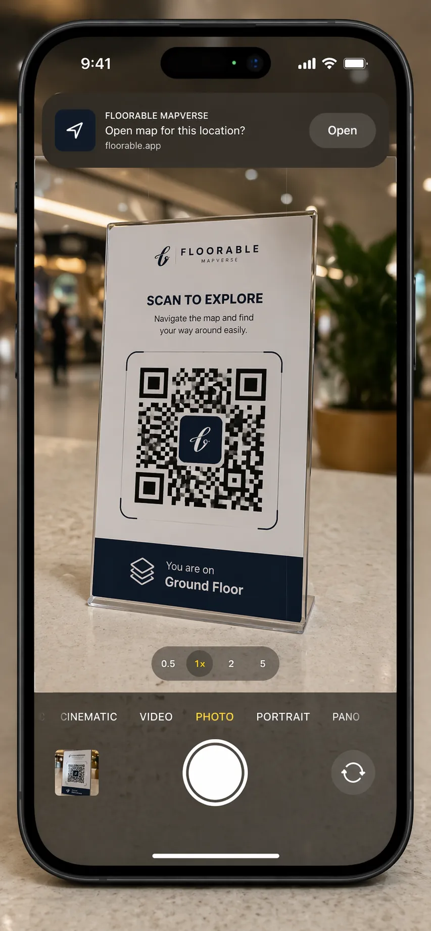
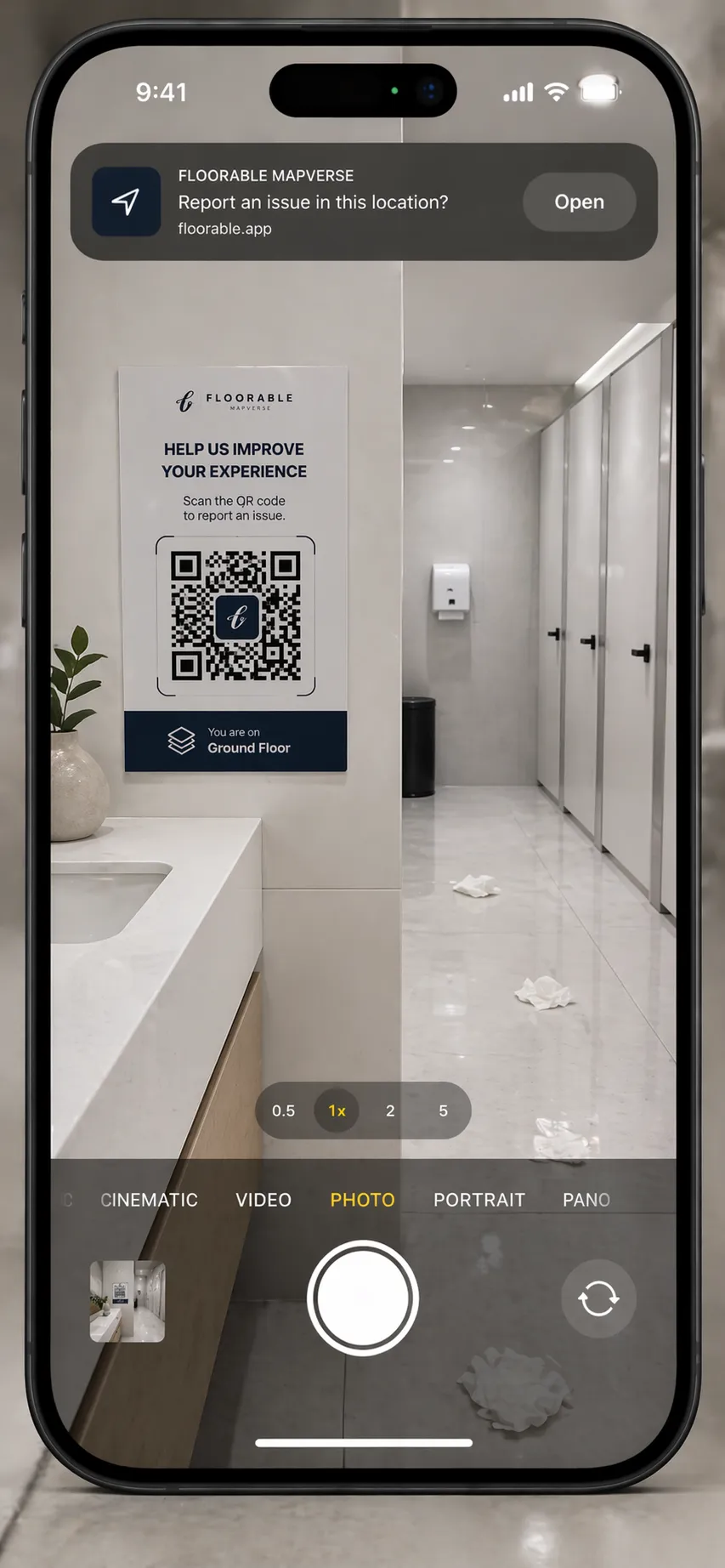
- QR Wayfinding Anchors: Instant "You Are Here" positioning for visitors via mobile QR scans—no app download required.
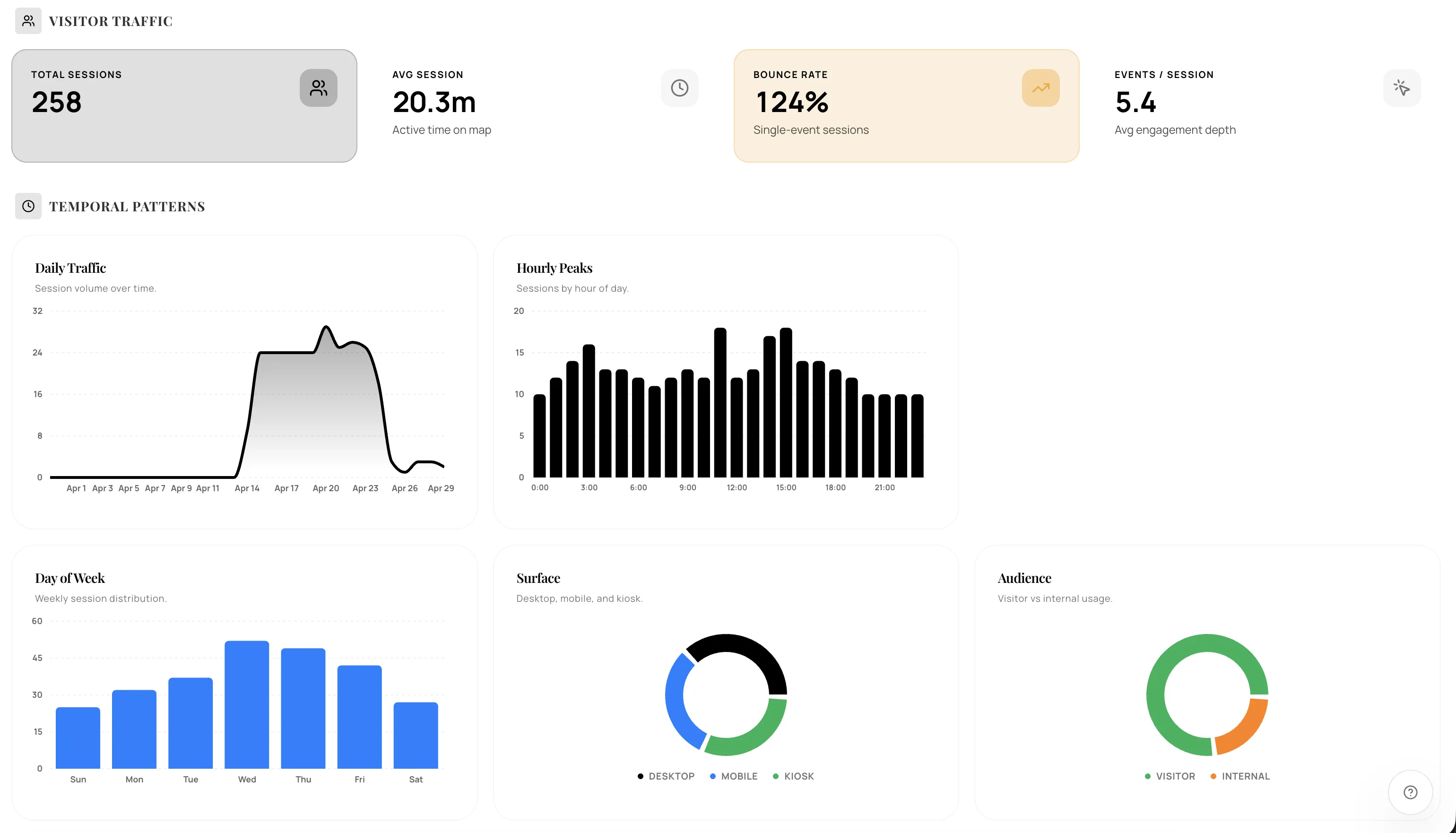
- Property Analytics: Deep insights into visitor search behavior, traffic patterns, and frequently navigated destinations.
- Unlimited Floors: A flat pricing model that allows mapping of entire facilities without per-floor or per-map penalties.
- Multi-Tenant Architecture: Secure, isolated environments for managing multiple properties and team permissions from a single dashboard.
Use Cases
- Primary Use Cases
- Retail & Malls: Guiding shoppers to specific storefronts, amenities, and parking while analyzing foot traffic patterns.
- Healthcare & Hospitals: Helping patients and visitors navigate complex corridors to find specific departments, clinics, or patient rooms.
- Higher Education: Mapping university campuses to assist students with classroom locations, event spaces, and accessibility routes.
- Corporate Offices: Managing large-scale workplace layouts, desk booking (via integrations), and internal facility maintenance.
- Industrial & Manufacturing: Documenting MEP (Mechanical, Electrical, Plumbing) assets and managing work orders in complex plant environments.
- Hotels & Resorts: Enhancing the guest experience with digital room wayfinding and spatial amenity discovery.
- Exhibition Centers & Museums: Providing interactive event maps and historical information pinned to specific physical locations.

Comments


The combination of indoor mapping and facility operations is compelling. The spatial ticketing angle feels especially practical for hospitals, campuses, and malls where wayfinding and maintenance usually live in separate systems. Curious how much manual cleanup is typically needed after the AI import step.

Floorable looks like a practical tool for people who want to visualize interior flooring designs before making renovation decisions. The interface appears clean and easy to understand, which lowers the barrier for non-professional users. One thing that stands out is the focus on simplicity. Instead of overwhelming users with complicated design software features, it seems to provide a more straightforward way to preview flooring options in a room. That could be useful for homeowners, DIY users, or small interior design projects. The product idea itself addresses a real problem: flooring decisions are expensive and difficult to reverse once installed. A visualization tool can help users compare styles and materials more confidently before purchasing. That said, the long-term value of the product will likely depend on factors such as rendering accuracy, available flooring libraries, mobile usability, and how smoothly the workflow performs with real room images. Overall, Floorable appears to be a promising and user-friendly concept in the home renovation space, especially for users looking for a faster and more accessible alternative to traditional interior design software.


The combination of indoor mapping and facility operations is compelling. The spatial ticketing angle feels especially practical for hospitals, campuses, and malls where wayfinding and maintenance usually live in separate systems. Curious how much manual cleanup is typically needed after the AI import step.


The combination of indoor mapping and facility operations is compelling. The spatial ticketing angle feels especially practical for hospitals, campuses, and malls where wayfinding and maintenance usually live in separate systems. Curious how much manual cleanup is typically needed after the AI import step.


The combination of AI and Computer Vision for indoor mapping is genuinely useful. Most mapping tools still rely on manual floor plan uploads — removing that barrier for hospitals and campuses is a real pain point solved. Curious whether the AI refinement step handles older buildings with irregular layouts well.
Really impressive approach to indoor mapping. The combination of Computer Vision with AI-assisted refinement for 3D wayfinding solves a real pain point for large facilities like hospitals and malls. Removing per-floor pricing barriers is a smart move that should accelerate enterprise adoption. Would love to see how it handles dynamic floor plan changes (renovations, temporary closures).
Combining Computer Vision with indoor mapping is a smart approach for facility-dense environments. The 3D wayfinding use case for hospitals and malls is particularly compelling — those spaces are notoriously hard to navigate. Curious how accuracy is validated after the AI refinement step, and whether maps can be updated in real-time as spaces change.
Combining Computer Vision with indoor mapping is a smart approach for facility-dense environments. The 3D wayfinding use case for hospitals and malls is particularly compelling — those spaces are notoriously hard to navigate. Would love to know more about how accuracy is validated after the AI refinement step, and whether the maps can be updated in real-time as spaces change.

Really solid project.Really solid project. The Computer Vision + AI refinement combo tackles a genuine pain point, indoor maps are usually either too expensive or too inaccurate. The unlimited floors pricing model is a smart differentiator that removes a major friction point for large facilities. Focusing on high-stakes environments like hospitals and malls gives it instant credibility and a clear niche. One thing worth exploring: how do maps stay current when a facility changes? That update pipeline could be a serious moat if solved well.


Bridging the gap between spatial mapping and facility management is a huge value add. Tying maintenance tickets to exact spatial coordinates seems like a game-changer for large-scale venues like airports or corporate parks that normally struggle with disjointed workflows. I'd love to know more about the data ingestion process—how well does the system handle complex or outdated floor plans during the initial setup?
Premium Products


Sponsors
BuyAwards
View all
Awards
View allMakers

Makers
Comments
The combination of indoor mapping and facility operations is compelling. The spatial ticketing angle feels especially practical for hospitals, campuses, and malls where wayfinding and maintenance usually live in separate systems. Curious how much manual cleanup is typically needed after the AI import step.
Floorable looks like a practical tool for people who want to visualize interior flooring designs before making renovation decisions. The interface appears clean and easy to understand, which lowers the barrier for non-professional users. One thing that stands out is the focus on simplicity. Instead of overwhelming users with complicated design software features, it seems to provide a more straightforward way to preview flooring options in a room. That could be useful for homeowners, DIY users, or small interior design projects. The product idea itself addresses a real problem: flooring decisions are expensive and difficult to reverse once installed. A visualization tool can help users compare styles and materials more confidently before purchasing. That said, the long-term value of the product will likely depend on factors such as rendering accuracy, available flooring libraries, mobile usability, and how smoothly the workflow performs with real room images. Overall, Floorable appears to be a promising and user-friendly concept in the home renovation space, especially for users looking for a faster and more accessible alternative to traditional interior design software.
The combination of indoor mapping and facility operations is compelling. The spatial ticketing angle feels especially practical for hospitals, campuses, and malls where wayfinding and maintenance usually live in separate systems. Curious how much manual cleanup is typically needed after the AI import step.
The combination of indoor mapping and facility operations is compelling. The spatial ticketing angle feels especially practical for hospitals, campuses, and malls where wayfinding and maintenance usually live in separate systems. Curious how much manual cleanup is typically needed after the AI import step.
The combination of AI and Computer Vision for indoor mapping is genuinely useful. Most mapping tools still rely on manual floor plan uploads — removing that barrier for hospitals and campuses is a real pain point solved. Curious whether the AI refinement step handles older buildings with irregular layouts well.
Really impressive approach to indoor mapping. The combination of Computer Vision with AI-assisted refinement for 3D wayfinding solves a real pain point for large facilities like hospitals and malls. Removing per-floor pricing barriers is a smart move that should accelerate enterprise adoption. Would love to see how it handles dynamic floor plan changes (renovations, temporary closures).
Combining Computer Vision with indoor mapping is a smart approach for facility-dense environments. The 3D wayfinding use case for hospitals and malls is particularly compelling — those spaces are notoriously hard to navigate. Curious how accuracy is validated after the AI refinement step, and whether maps can be updated in real-time as spaces change.
Combining Computer Vision with indoor mapping is a smart approach for facility-dense environments. The 3D wayfinding use case for hospitals and malls is particularly compelling — those spaces are notoriously hard to navigate. Would love to know more about how accuracy is validated after the AI refinement step, and whether the maps can be updated in real-time as spaces change.
Really solid project.Really solid project. The Computer Vision + AI refinement combo tackles a genuine pain point, indoor maps are usually either too expensive or too inaccurate. The unlimited floors pricing model is a smart differentiator that removes a major friction point for large facilities. Focusing on high-stakes environments like hospitals and malls gives it instant credibility and a clear niche. One thing worth exploring: how do maps stay current when a facility changes? That update pipeline could be a serious moat if solved well.
Bridging the gap between spatial mapping and facility management is a huge value add. Tying maintenance tickets to exact spatial coordinates seems like a game-changer for large-scale venues like airports or corporate parks that normally struggle with disjointed workflows. I'd love to know more about the data ingestion process—how well does the system handle complex or outdated floor plans during the initial setup?
Premium Products
New to Fazier?

Find your next favorite product or submit your own. Made by @FalakDigital.
Copyright ©2025. All Rights Reserved